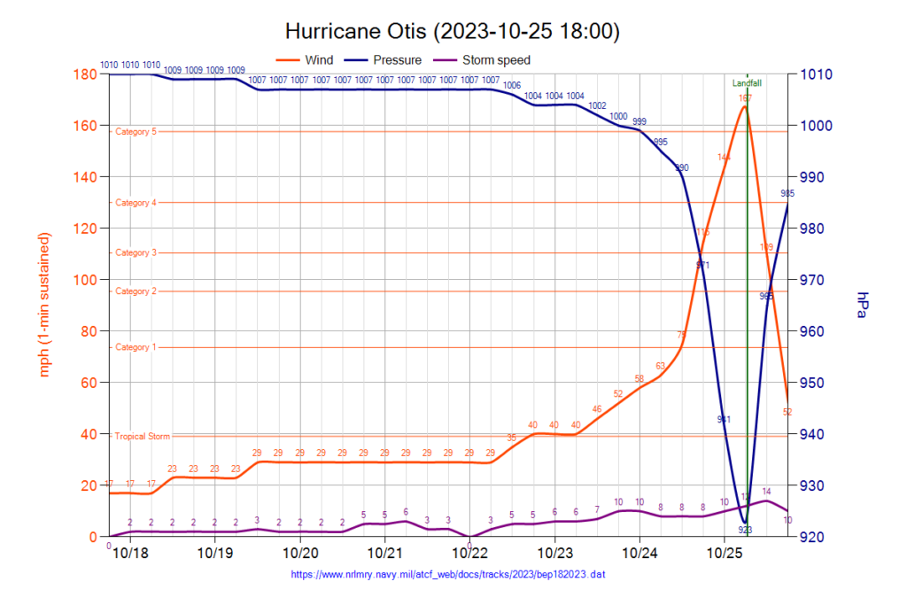
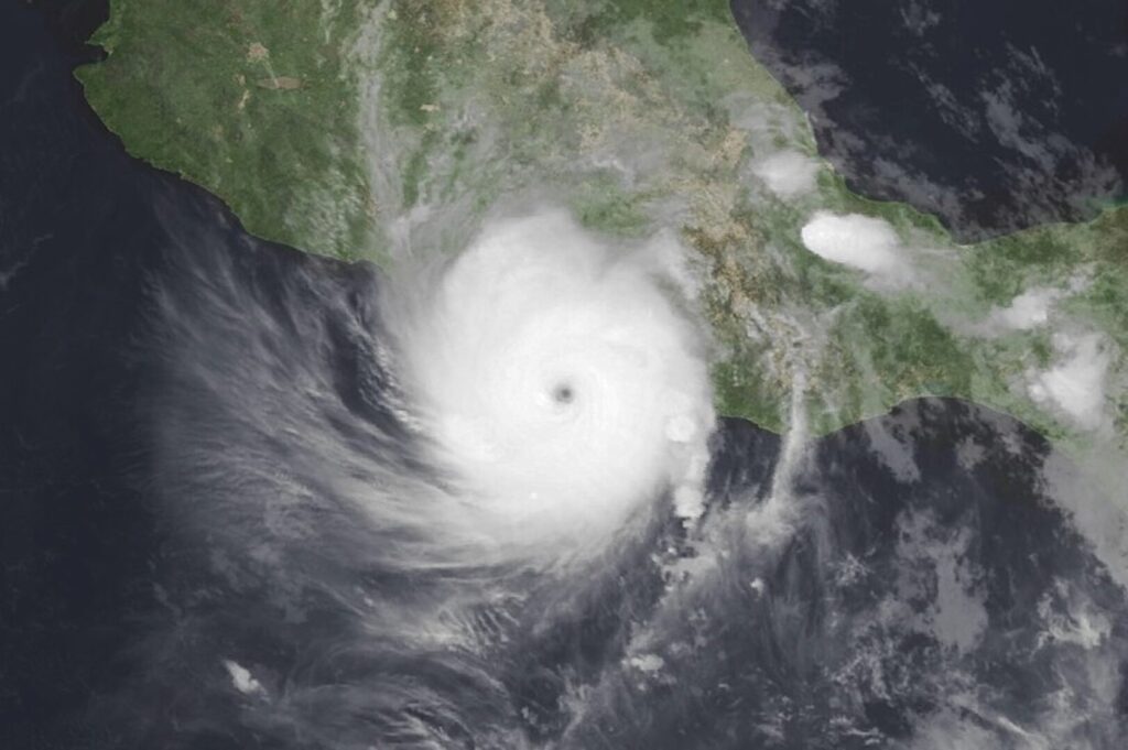
In less than 12 hours, Otis went from being a tropical storm at hurricane most powerful earthquake that has ever hit Mexican soil, when it made landfall at Acapulco with maximum sustained winds that reached 265 kilometers per hour, without any forecast model anticipated.
In an article published by Wired, Jorge Zavala Hidalgodirector and researcher of the Institute of Atmospheric Sciences and Climate Change in the UNAMThe author argues that this phenomenon makes it necessary to consider the limitations of the forecast modelsIf there is any issue that is not very well known and that this hurricane has exposed, to improve them.
"We don't know very well why the intensification was not accurately predicted, we have to do a careful analysis," he points out.
It is necessary, he says, to review whether the information that was available to feed the models was adequate, both initial and boundary conditions.
The scientist explains that at 6:00 p.m. on October 23, forecasts from various international agencies and research groups suggested that Otis would only be a tropical storm. No computer model showed red flags.
Six hours later, in the forecast update, they insisted that it would be a tropical storm. Only two predicted that it would become a category one hurricane. By 12:00 p.m. on Tuesday, October 24, the phenomenon was between the border of categories two and three, although six hours earlier no one noticed that it would reach category two.
The forecast took a turn on Tuesday after hurricane hunter aircraft flew over the storm and showed that the intensity was greater than what was seen in satellite estimates. On Tuesday night, from the National Hurricane Center Otis was described as a "nightmare scenario". Finally, the meteor entered Acapulco, Guerrero with category 5, the highest category.

From being a storm with winds of 111 kilometers, Otis experienced an explosive intensification to become a monster within 12 hours with maximum sustained winds of 265 kilometers per hour, according to the Specialized Meteorological Center of the World Meteorological Organization (WMO).
"It was category 5 and phenomena of this level are few, rare. The cyclone made landfall with the highest classification, when it is usual for these phenomena to reach the maximum category far from the coasts and weaken as they enter the continent, but without a doubt its most memorable feature will be to have changed so much in such a short time," explains Zavala.
Good information is vital for forecasts
In order to predict how a meteorological phenomenon will evolve, it is vital to have good information on both the cyclone itself and the environment where it occurs.
The UNAM scientist explains that these tools are based on dynamics and thermodynamics equations. With correct data and effective interpretation, experts can determine the trajectory. And if they have a good picture of the state of the atmosphere, they can predict how it will evolve in the coming hours.
"We have to review whether the information was incomplete or what happened," Zavala says of the Otis case and the failure of the forecast models.
There are reports indicating that the radar is not operating. Acapulcowhich would provide information on the winds, the position of the center of the hurricane and a little of the vertical structure of the cyclone, useful data to estimate how it will evolve.
Climate change and extreme events
The WMO has warned that the climate change is altering nature in a dangerous and pervasive way and that the amount of extreme events values never observed before and will increase as the number of employees increases. global warming.
Zavala Hidalgo explains that cyclones tend to form in tropical waters and are fueled by thermal energy, so they need warm water and moisture to grow, so when the oceans burn, as during the current hurricane, they can be very hot. El NiñoThere is greater availability of energy.
For a hurricane to quickly become more intense, Zavala explains, a layer of warm, deep water is needed. However, to identify the temperature, a team of people is needed to monitor the heat content of the sea by analyzing satellite data and knowing the region.
The scientist argues that in such a context and with the experience that has left OtisIdeally, the ideal is to have enough information to make good decisions in advance.
Source: Wired


